The area of
our present St. Mark's started life as a rural part of the Township
of Nepean. After World War II, it was simply a few farms, a small
commercial development at the intersection of what was then the
Prescott Highway and Hog's Back Rd, and cottages crammed into the
area east of Hog's Back Falls and along the eastern and western shores
of the Rideau River. The main streets of the area were the Prescott
Highway (Prince of Wales Dr), Baseline Rd, Fisher Ave, Dynes Rd, and
the Borden Side Rd. The next development west was City View on Baseline
and Merivale. Merivale had a fringe of houses along its length. The predominant
farms were the Nesbitt, Moffat, Borden, Stewart, Mulligan, and Leiken
farms.
A full early history of this area is contained in the The City
Beyond, A History of Nepean, Birthplace of Canada's Capital, 1792-1990,
by Bruce Elliott and published by the City of Nepean.
A young fool
diving at Hog's Back.
I first got to know the area in 1948 as a young 18 year old, newly
enlisted in the Royal Canadian Air Force (RCAF) and transferred
to the RCAF Station Rockcliffe. Hog's Back was our swimming hole. On
the weekends or holidays, we took the Eastview bus and then the Ottawa
bus to go to Hog's Back for swimming. It was good swimming. Although
the beach was really postage stamp size, it never seemed to be too crowded
for one more. And yes, in those days we stupidly dove head first into the
swirls below the Falls. Other than swimming, the only thing that sticks
in my memory is the hamburger places on the Highway. I had no idea at that
time that the area would play such an important part in my life in less than
five years.
Things were happening in the area. The Canadian Government was worried
about returning veterans and how to integrate them back into society.
They were also concerned about a depression following the war and
the devastation that it would have on the veterans.
The Veterans Land Act (VLA) was passed into law in 1942. Its purpose
was "to assist war veterans to settle upon the land." As the Department
of Veterans Affairs states, it was one of three pieces of rehabilitative
legislation enacted as part of the government's overall program to
re-establish veterans into civilian life.
The original intent of the VLA was to assist qualified veterans to
become farmers, but provision was made in the Act for settlement on "small
holdings," or single family dwelling size lots. Our Carleton Heights
VLA development was part of over 140,000 returning veterans who were
established under the Act.
The Department of Veterans Affairs decided that they would establish
a VLA site just south of the Hog's Back Rd in the Township of Nepean.
It was named Carleton Heights. They purchased the Nesbitt and Moffat
farms totalling 434 acres, and laid it out in one-half acre lots with
enough room for the veterans to have a large garden, raise goats and
chickens, and keep bees. This was done so that the veterans could feed
themselves in the event of a depression. Cynthia Greer, our present People's
Warden, reports that there are still some households keeping chickens
in 1999, which is amazing in an urban setting. Carleton Heights was developed
in two stages with the part east of Fisher Ave being built mostly between
1945 to 1950 and the part west of Fisher Ave between 1950 to 1955.
The street names of Carleton Heights were chosen to honour battles
of World War II (Ortona, Normandy, Falaise, Arnheim, Senio, and
Apeldoorn) or in the case of Skeena to honour the RCN and HMCS Skeena.
There were other names. Nesbitt was named after the Nesbitt family
and according to Bruce Elliott, part of it follows the path of the original
farm laneway. Claymor was apparently named for the clay.
The streets in the Carleton Heights area were listed in the Greater
Ottawa Directory as: Apeldoorn Ave, Arnheim Ave, Claymor Ave, Falaise
Rd, Falls View Rd (north off Hog's Back Rd on the west side) Fisher
Ave, Hog's Back Rd, Melfa Cres, Minaki Cres, Nesbitt Ave, Normandy
Cres, Ortona Ave, Prince of Wales Dr, Senio Ave, Skeena Ave, Stormont
Ave, and Valmarie Ave. Falls View Rd does not exist now.
The VLA houses were all Central Mortgage and Housing Corporation
(CMHC) plans. Bruce Elliott records that the first major start was
made by Hill-Clark and Francis Contractors who undertook to build
88 houses of the 1-1/2 storey and bungalow designs. They were started
in 1945 but they were not completed until 1947 because of a shortage
of material. The first families moved-in in 1947. Many of the houses have
had additions put on since then as they are very small by today's standards.
The majority of houses, however, were built by the veterans themselves
either using their own contractor such as Boyd Brothers, or actually
doing the work themselves. Three brothers, George, Alex, and Bill
Michie help each other build the shells and close in their houses.
When the houses were closed in, the Michie brothers each took over the
finishing of their own house.
One area west of Fisher Ave on Argue Dr was built as a co-operative
venture by the veterans themselves with the cooperation and help
of VLA. They bought enough materials to build or equip 29 homes, such
as 29 front doors, 29 furnaces, etc. This way they were able to get
much better prices. When the 29 houses were finished, they drew numbers
to see which home was theirs. There were only 2 designs, which were
only slightly different from each other. Bruce Elliott records that
Argue Drive was named for Frank Argue, who died of cancer during the building
of the co-operative houses.
VLA authorities installed municipal services for the houses. Three
wells on Ortona provided the water and a sewage plant was built
on the Rideau River.
While the veterans of Carleton Heights were busy building houses
and scraping mud, the City of Ottawa and the Township of Nepean
were in annexation negotiations. Since 1890, Ottawa had annexed parts
of Nepean nine times and it was not over yet. Indeed, Nepean Township
originally extended westward from the Rideau River and Gloucester extended
eastward. So all of the area of Ottawa came either from Nepean or Gloucester.
In 1949 the City of Ottawa ended at Western Ave on the West and essentially
Carling on the south. Ottawa wanted to annex south to Black Rapids and west
to Greenbank. It would have taken the urban core out of Nepean and left it
mainly as a rural township, again. After some very bitter fights, Ottawa
and Nepean agreed that the area to be annexed would be east of Fisher (except
for 120 feet on the west), north of Baseline (except for 120 feet on the
south) and west to Greenbank. Essentially these are the borders we have in
our area in 1999. The Ontario Legislature passed the City of Ottawa Act in
1949 and it came into effect January 1, 1950.
In 1950, the area just south of Baseline Rd and west of Prince of
Wales Drive started to be developed. It was part of the Mulligan
farm. It was called Courtland Park. It included Baseline Rd, Wilshire
Blvd, Chandler Ave, Sanford Ave, Hudson Ave, north side of Lexington
St, and Morley Blvd. The houses, constructed by James More Construction,
were 1-1/2 and 2 story houses. A central well was installed at the
end of Lexington Ave to provide a source of water. It turned out to
be an artesian well with natural fluoridation. The houses were on septic
tanks which forced the large lots that still exist today.
After Courtland Park, Fisher Heights was started in 1953. The houses
were CMHC new design three bedroom bungalows and a few of the standard
1-1/2 story houses. The land was the Leiken Farm, which had its main
farm buildings near Woodrooffe and Baseline. The Leiken Farm was
originally owned by J.R. Booth, a prominent businessman in the lumbering
days. The lots were 90 by 100 feet and because the development had
wells and septic tanks, building was done on every other lot. Real estate
agent Jack Aaron is credited by historian Bruce Elliott as finding the
loophole which would permit the building on every other lot to meet
the regulations for wells and septic tanks. The in-between lots were
reserved by the developer for future sale when municipal services became
available. In an unusual move, a separate contractor built each interior
block, i.e. Lipstan and Oakwood, Lipstan and Kesler, etc.
Lot pattern in Fisher Heights in 1958.
2 Lipstan is the black roof
closest to the centre.
We bought our home and moved into Fisher Heights in 1953. The abiding
recollection is mud; sticky, gooey white clay mud. If you walked
on the clay when it was wet, it stuck to your rubber boots and you
gradually built yourself a pair of elevator shoes. But be that as it
may, that clay grew great crops. As an example, we had a 100 foot long
raspberry row (Newburg variety) and we continually had over 100 quarts
of berries each year. Raspberries came out of our ears! Our "greatly improved"
black soil in later years never produced that good a crop.
We were the fourth family to move in. Fisher and Baseline were both
two lane gravel roads. We had buses to the city in the morning and
at night. The area between us and the Church on the south was a vacant
field. The AutoSky drive-in was at the corner of Baseline and Fisher.
We picked up our mail at Jack & Ruby Lippett's IGA at the north-east
corner of Hog's Back Rd and the Prescott Highway, right next to Monty
Montgomery's service station. In 1953, we were thrilled to have the Lancaster
Shopping Centre built on Merivale Rd because finally we had a local hardware
store.
Basement at 2 Lipstan in 1953
with Courtland Park in the distance.
The closest thing to a tree
was a telephone pole!
The vacant lots were offered for sale for $325 in 1953. We didn't
have that kind of money, but we did buy in 1956 for $900. The last
lot sold in Fisher Height for $76,000 in the mid-70s. Those lots which
were not sold to individuals were alternatively bought by Minto, soon
to be the predominant developer in the area.
The Hog's Back area underwent dramatic change. The cottagers who
had leased land from the National Capital Commission had their leases
ended. The cottages were removed and the area east of the Rideau
River was turned into open space. The area to the west of the River
was destined to be large apartment buildings, and indeed 1456 Prince
of Wales Drive is the largest apartment building in the area. It stands
where the old Falls View Road used to run. And of course, swimming
was banned at Hog's Back after Mooney's Bay beach was opened. Fences
were erected at the Falls so young fools couldn't dive in any more.
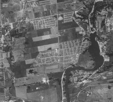
Area in 1959. North is at the top. Locate the Autosky
Drive-in near the top centre (looks like a fan).
It is at Fisher and Baseline. To the left is Fisher
Heights,
to the right is Courtland Park. Down is Carleton Heights.
Baseline, Fisher, Prince of Wales, Merivale (on the left), Dynes,
and the Borden Side Rd are the major roads.
RCAF Photo.
Water and sewer came into the entire area in the early 1960s as a
result of an initiative of builders and developers lead by Irving Greenberg
of Westmore Investments, later known as Minto Development Corporation.
Greenberg suggested that developers and contractors contribute the
money to build water and sewage facilities. The Township of Nepean
met with a group of them and an agreement was reached. With water, sewer,
and the land available, major construction of houses could start: These
were Parkwood Hills from 1959 to 1972, Borden Farm from 1967 to 1976,
and Fisher Glen from 1981 to 1984. On the Ottawa side, Murchison Place
(Courtland Park to Dynes) in 1962 to 1968 was a built as a VLA Part B development,
although few today use the name Murchison Place. The Part B plan had
fewer strings attached and the lots could be smaller in size.
Minto, lead by brothers Irving and Gilbert Greenberg, are a huge
part of the next twenty years of development in the area. Minto
developed Parkwood Hills and built on the vacant lots in Fisher Heights.
Skyline and the apartment buildings on Meadowlands were built, of
course after Meadowlands came into existence. Then followed Borden
Farm and Stewart Farm, all by Minto. Other major developers were Assaly
for the apartment buildings on Dynes and Prince of Wales, Bellcourt for
the apartment buildings at Hog's Back Rd and Prince of Wales, and Steenbakkers
for the south side of Dynes. The City of Ottawa built rent to income
houses in the Prince of Wales and Meadowlands area.
The air photo above shows the four developments in the late 50s.
Note that there is no Meadowlands. The area between the developments
was farm fields producing crops.
The area in 1949 had about 300 or so permanent houses on about 10
streets. By 1998 the Parish neighbourhood area from Baseline on
the north, Merivale on the west, the Rideau River on the east, and
the Nepean Creek (just south of Viewmount, Coolspring, and Valley Ridge)
had grown to be a small city. There are 140 streets and 7600 or so households.
Statistics Canada in 1998 gave the average density as 2.85 person
per households to give a total population of about 21,500.
Written by Lorne Bowerman
with help from many
|